
Puget Sound Convergence Zones typically occur when the low-level winds on the coast are from the west to northwest, peel around the Olympics, and then converge over Puget Sound. The converging air streams cause upward motion, and thus clouds and precipitation. Spring is the big season for convergence zones: westerly winds are more frequent than any other time of the year and the air is often unstable, which gives lots of clouds/rain when the air is given an upward nudge.
Such conditions were evident yesterday (Wednesday). A satellite image around noon showed the telltale signs of a convergence zone with a band of clouds across the north sound and clear zones to the north and south. Why clear? Due to sinking on the Olympics mountains and the mountains of Vancouver Island.

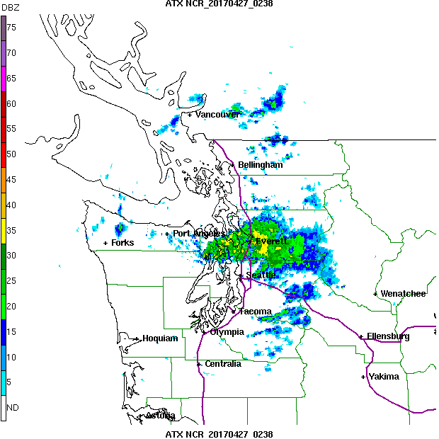
The convergence zone held into the early evening, as suggested by the Camano Island radar image at 7:30 PM. Wow...that is a nice band of precipitation north of Seattle!
Convergence zones typically drop modest to heavy precipitation from north Seattle to Everett, and this one was no different. To illustrate, here is the 24-h precipitation ending 5 AM Friday morning. A few hundredths of an inch over south Seattle, a half inch north of the ship canal, and roughly an inch over Snohomish county. Even more around Monroe and the Cascade foothills.

A radar-derived 24-h precipitation total from Seattle RAINWATCH suggests a similar picture.


For example, here is the 27-h forecast of the 3 hr precipitation ending at 8 PM Wednesday from the high-resolution (1.3 km grid spacing) UW WRF model forecast started on 5 PM Tuesday....very nice convergence zone.


A decade ago we couldn't make such skillful forecasts, but today it is not an outlier. It represents the impacts of better data and use of data over the Pacific Ocean, higher resolution models, better model physics, and much more.
The Puget Sound Convergence Zone got me interested in NW weather and I still find it fascinating.


In real world terms, in Woodinville, a freshly dug French drain trench (15' long x 1' wide x 8" deep") received 11k cubic inches of water in ~12 hours (as of 11am Thursday). That's equivalent to ~48 gallons or one-and-a-half standard bathtubs of water.
ReplyDeleteHere in Bothell, we got .82"
ReplyDelete