November 29, 2014

Arctic Blast Hits Washington State

With the passage of what local meteorologists call a Modified Arctic Front, our region has been hit with plummeting temperatures, low humidities, and very strong northerly winds, with some locations experiencing gusts over 50 mph.   Over 30,000 customers have lost power from the winds and snow is falling on the northern side of the Olympics.

The Arctic front was associated with large pressure gradients between the interior of British Columbia and Washington State, results intense wind acceleration in the Fraser River and Okanogan River gaps. (see NWS pressure/frontal analysis and UW WRF temperature/pressure forecast for 10 AM Saturday)


The max gusts (mph) for a subset of western WA stations is shown below:  strong winds (gusting to 40-60 mph pushed out the Fraser Valley across Bellingham to Blaine and  accelerated over the water. Some pushed into the Strait and other strong winds headed southward into Puget Sound.  Can you imagine if there had been a big coal pile north of Bellingham at the proposed Cherry Point site?   The dust plume would have spread to the southwest toward the San Juans....

 In eastern Washington, even stronger winds extended southward out of the Okanagan and pushed to Oregon along the eastern slopes of the Cascades.   Rattlesnake Mountain above the Tri-Cities had a max gust of 96 mph!


Winds along Puget Sound and Lake Washington have been vicious, with white caps galore.

If you want to experience, the power of the current winds check out this wonderful high-def video by the areas leading weather-cam enthusiastic, Greg Johnson of Skunk Bay Weather (click on image or link)

I was just a Magnuson Park...it was amazing out there, with big waves and white caps...and an excellent rescue of a boater by a Coast Guard helicopter and a Seattle Police boat.  As I write this, large branches are falling off evergreen trees in back of my house.  Northerly winds over Puget Sound at West Point (see below) hit 41 knots (47 mph)...which is a VERY strong wind speed from the north. I have heard of substantial erosion on the north side of the Kitsap at Hansville and on northern Bainbridge Is.


 But the strongest winds are now over and we can expect things to settle down this afternoon.  The pressure difference between Bellinghan (BLI) and Kamloops, BC has dropped considered from its peak of 15.22 hPa (8.4 hPa and hour ago)

Northerly winds tend to cause more branches to be lost than southerly winds at the same speed, since trees are far more accustomed to strong southerlies in our area.

The upslope flow has ended between Sequim and Port Angeles, where 2-6 inches fell (see cam for a location between Sequim and Port Angeles):

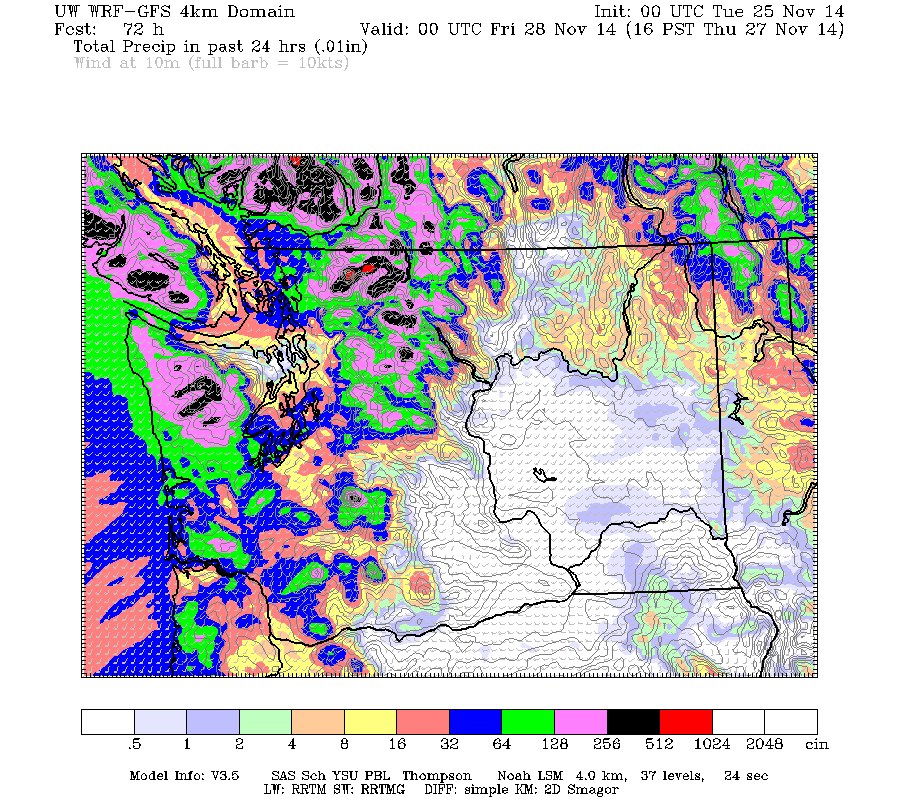
There will be no precipitation the next two days, with temperatures falling into the mid to lower 20s in western Washington.


November 27, 2014

Northwest Residents Travel from Hawaii to the Arctic Without Going to the Airport

In one day, Northwest residents will go from breathing air that been over Hawaii and vicinity to air that has passed over the Canadian Arctic, and will do so without having to move an inch.  Hawaii and the Arctic will come to them. Far better than a Rick Steves travel  video...you will be breathing the real thing!

Today, I was working outside after putting a turkey in the oven...it was TROPICAL outside, with humid air approaching 60F.  Many local reporting stations exceeded 60F, with some in the Tri-cities hitting 70F.  It was 73F in Honolulu at 3 PM.


The tropical air came in on Tuesday with an amazing warm front.  Here is a trace of the wind speed, wind direction, temperature, and dew point temperature that day.  Around 01Z (about 5 PM), the temperature increased about 8F in an hour, the winds shifted to the south, and wind speed increased rapidly.  A magnificent warm front--a rarity here in the NW.


We can see exactly where the air over Seattle has been coming from using the NOAA Hysplit model.  Here is a trajectory (the path of the air) ending over Seattle at 4 AM Thursday for a period of 96 hour.  Started a bit northeast of Hawaii.

And the atmospheric moisture for 10 PM Wed. night shows a plume of subtropical/tropical moisture heading right for us.  This is known as an atmospheric river...and in this case the Pineapple Express.

So you have been breathing moist, warm Hawaiian air if you have been living in the Pacific Northwest the last few days.  No need for jet travel.

But everything will change radically on Friday.  The Arctic is coming...to YOU.


 Early Friday afternoon a strong cold front...in this case an ARCTIC FRONT...will be moving into western Washington.  Here is the latest WRF model prediction valid at 8 AM Friday:  big temperature drop behind it, although the coldest air (purple and brown) is still in British Columbia.


The front will move southward during the day and by Saturday at 4 AM, we will have modified Arctic air entering the region (see graphic).

 And by 4 AM Sunday, the cold air has flooded Washington State and Montana, and pushing south into Oregon.

 As the front moves though, we will switch from southerly to northerly winds and the trajectories will change with them. Here is is trajectory for air ending at 1000 meters above Seattle on Saturday morning at 4 AM.   Started in the Yukon!  Then moved to the coast before heading over Seattle


And what about snow?  Right now if looks like the temperatures will be too warm for snow in the lowlands of western Washington on Friday, but there will be plenty of precipitation in terms of rain.

Here is the 24h snowfall ending 4 PM Friday.  Lots in the mountains but nothing near sea level.
On Friday night and Saturday it will be cold enough to snow, but precipitation will be sparse....thus only very light snow west of the Cascade crest, with the NE Olympic Peninsula being favored, as will a band north of Seattle in a Puget Sound Convergence Zone.  If the upper level trough approaching on Saturday is displaced farther to the SW, there could be much more snow....so keep in mind there is some uncertainty with this forecast.

Temperatures will plummet over the weekend, with highs in the 30s.  Here are the forecasts from the National Weather Service and the Weather Channel....both pretty similar.


November 26, 2014

Lowland Snow Threat on Friday Afternoon and Saturday

There is a four letter word one tries to use sparingly in Seattle: SNOW.

The mere mention of this solid form of water causes our local media to go wild and anguish to furrow the brows of Seattle mayors.

But there is a chance for light lowland snow on Friday afternoon and Saturday morning, but uncertainties (as always the case with western Washington/Oregon snow) are substantial.   However, the ingredients will be in place, the only question is whether they will combine in the right way.


So what are the ingredients we are looking for?  First, you need cold air...you can't get snow in the western lowland without that!  And you need precipitation.    We have two separate shots at getting the combination.   Let me tell you about it.

First Friday afternoon at 1 PM.   Take a look at the sea level pressure, lower atmospheric temperature (at about 3000 ft above sea level), and surface (10-m) winds.  Blue and purple indicate air cold enough for snow.  A strong cold front is pushing southward into western Washington.  This front will have substantial precipitation with it, and much colder air behind. There will be a period after frontal passage when both cool air and precipitation will be in place.  And precipitation will be heavy enough that cooling due to melting may help bring down the snow level.


The cold front will be aided by an approaching weak upper level trough (see 500 hPa weather map, around 18,000 ft)


The UW WRF model (24h amounts ending 4 PM Friday) is forecasting some snow over the lowlands with the fron, with LOADS of snow in the Cascades (up to a foot)


Then the next day brings the main upper trough swinging through, a trough that would cause upward motion and some precipitation (snow).  4 AM Saturday morning is shown.

The surface chart indicates that the air would be plenty cold for snow...the question is precipitation.


Here is the 24h snowfall ending 4 PM Saturday. Light stuff in the lowlands EXCEPT for heavier snow on the NE side of the Olympics as strong northeasterly flow from the Fraser River Valley collides with the Olympics.  You will feel sorry for those poor folks in Sequim and Port Angeles.  No golf.  And several inches in the Cascades.


Snow forecasting is very difficult around here because it is hard to get cold air and moisture together in the right way.  But both ingredients will be available during this period and there is certainly the potential for light lowland snow.

But there is a lot of uncertainty in this forecast.   For the first event, we are on the edge for temperature, but precipitation will be there.  For the second, the temperature will be cool enough, but precipitation is in question.   This is not an unusual situation for snow around here.

Don't forget about the potential for strong northeasterly winds pushing out of the Fraser across the San Juans and then against the Olympics.  Gusts could reach 40-60 mph.  Here are the sustained winds for 1 AM on Saturday morning...35 knots hitting the northern San Juans.  I would not be surprised if some folks there lose power.


And there is something else.   The ground and road surfaces are very warm right now, particularly after a warm fall and the near 60F temps of the last few days.  Seattle wisely put a number of road temperature sensors in a few years ago, what do they show?

 Here is a plot of current air and road temperatures (in the boxes) around Seattle. Yikes!  The road temperatures are in the mid to upper 50s!  The elevated sections will cool relatively quickly 10-20F in a day, but road surface in contact will the ground will cool far more slowly.  Light snow will tend to melt quickly even without any pretreatment.


November 24, 2014

Heavy Precipitation, Flooding, and a Cascade Meltdown

Yes, a typical Thanksgiving in the Northwest.

During the past week, we were encouraged by the first real snowfall in the Cascades this fall, with some locations getting 20-30 inches.  Steven Pass, hit by some convergence zone precipitation, has 24 inches and is just short of opening.  But like a snow mirage, the Cascade snowpack is about to disappear as warm temperatures and heavy rain hits the mountain barrier.
The current NOAA snow analysis shows 5-30 inches in the Cascades

Some mountain locations will get 5-10 inches of RAIN before the next few days are up and several rivers draining into Puget Sound will hit flood stage.  Winds get blustery over Northwest Washington and downright windy along the coast.   Normal weather that will make for a cozy Thanksgiving dinner or some personal time with a book or tablet.

Today (Monday) was a day of profound rainshadowing with westerly flow approaching our region, with the precipitation associated with a warm front.
Seattle got almost nothing, while the western slopes of the Cascades and Olympics enjoyed .3 to 1.5 inches.  Less rain in Seattle than Sequim with such westerly flow...you got to to like that.


But all hell is about to break loose, precipitation-wise, and because of the warmth, temperature-wise. Skiers in particular will curse the approach of the evil one.

Stage 1 has already begun.  Warm, moist air immediately behind the warm front is flooding in aloft, but the flow will remain westerly.   Over the next 24-h, heavy precipitation will hit Washington, with as much as  2-7 inches in the central and southern Cascades.  Puget Sound will be substantially rain-shadowed by the Olympics.

Then on Wednesday, Stage 2 will commence as strong, moist southwesterly flow pushes over our area.  Here is the temperature and wind field at 850 hPa (around 5000 ft)...warm, strong juicy flow.  Red..the color of the devil..is warm.


And the moisture field over the eastern Pacific shows a modest atmospheric river...a narrow plume of high water vapor content headed right for us, after starting near Hawaii.

The precipitation for the next 24h (ending 4 PM on Wednesday) shows the rain hitting the north Cascades and Vancouver Island fairly hard, with 1-3 inches and a substantial rainshadow northeast of the Olympics.
In stage 3, the atmospheric river strengthens, as does the precipitation (here are the total for the 24 h ending 4 PM Thursday. 2-5 inches in some places.


Add the entire 72h together over the region and here is what you get:  5-10 inches over the north Cascades, Vancouver Island, and the extension of the Cascades into BC.  Less over the Puget Sound lowlands and practically nothing from Yakima southward on the eastern slopes.


The freezing level will be above 7000 ft for most of this period, as high as 8-9 thousand feet at times.  That means no snow.  And with warm air and strong winds aloft, the mountain snows will melt quickly.

With lots of rain and snow melt, the National Weather Service has a flood watch now:

And the National Weather Service River Forecast Center is predicting flooding on several major rivers draining into Puget Sound, like Snoqualmie, Snohomish, Stillaguamish, Nooksack, and Cowlitz.

This is not going to be megaflood event like the November 2006 or the January 2009 events.  But if you live near ones of the above rivers, please take precautions.

The snowpack is going to be radically reduced.

But there is so much more.   The atmospheric river will then head south to California, where they will get a major precipitation event--which is sorely needed.

And cold air may come back this weekend, with the possibility of lowland snow west of the Cascade crest!

As they say, when it rains, it pours....


Ask a question to be answered on-air on KPLU

Would you like to ask a question that I could answer during my radio show on Fridays at 9 AM?  You can submit it on this website.   The segment is repeated later during that day as well.  KPLU is 88.5 Mhz for most of you and you can also listen online.

November 22, 2014

When sun in Seattle is good sign for snow in the Cascades

Life has its seeming contradictions.

There was some nice sun in Seattle this afternoon and that was ironically a good sign for mountain snow lovers.   How could that be true?

First, the sun...here are a few cam shots Saturday afternoon..one looking at Seattle from Queen Anne and the other from the UW.


There were even blue skies, particularly over the Sound and the Kitsap Peninsula...a visible satellite image around the same time confirms this:

But at the same time, it was completely cloudy over the Cascades and the Olympics, with snow falling from roughly 3500 ft and above.  As proof, here are some cam shots at Crystal Mountain and Stevens.


Is there a connection between Seattle sun and Stevens/Crystal snow?  
You bet there is.

After the front went through Friday night the winds aloft turned from southerly and southwesterly to westerly and northwesterly.   I can show this change from the winds above Seattle-Tacoma Airport shown in the following image.  The winds are shown by the pennants and temperatures are in red. The vertical axis is pressure (850 hPa is about 5000 ft, 700 hPa about 10,000 ft.  The x-axis is time in UTC (22/06 is 10 PM Friday night). The front was associated with a wind shift and the rapid decline in temperatures aloft.


The Cascades are oriented roughly north-south and thus westerly winds (from the west) are forced to rise on  the mountains sharply since the winds are directly right up the height gradient.  That rising motion produces cooling and saturation, resulting in clouds and precipitation, and in this case snow! Southerly winds do not ascend the mountain much.

When air goes DOWN \terrain it warms, dries and clouds dissipate.  For westerly or northwesterly flow, like we had this afternoon, the air rises on the Olympics (producing clouds and precipitation on the western side of those mountains), but sinks on the eastern side of the Olympics, producing clearing skies west of and over the Sound.   The westerly flow then rises again on the Olympics giving snow.

You seen this happening in a recent weather radar image.  Dry over Puget Sound, but lots of precipitation on the western slopes and crest of the Cascades.


So Seattle's clearing is a good indication of strong westerly flow and thus good potential for snow in the Cascades  if the air is cold enough.

I know...you want to know how much snow will fall before Thanksgiving.  Here is the predicted total snow for the 72 h starting 4 AM today (Saturday). 1-2 feet in some locations of the central and northern Cascades.  I am pretty sure there won't be enough for Snoqualmie, but perhaps for Stevens, Baker, and Crystal.  But it will be close.  But there is a problem....warm air is coming.

..........................................................
And if any of you would like to read about on snow in mountains, there is a very good book on mountain snow that has just come out:

Secrets of the Greatest Snow on Earth: Weather, Climate Change, and Finding Deep Powder in Utah's Wasatch Mountains and around the World


This is written by a colleague of mine (and a graduate of my department) Professor Jim Steenburgh of University of Utah.  This book not only explains why Utah's mountains enjoy such good snow, but describes the mechanisms of mountain snow, avalanches, and many other general snow topics. And there are lots of marvelous pictures.  Jim is an expert in mountain meteorology, is crazy about mountain snow, and has spent an extraordinary amount of time skiing.

Ordering information:

Barnes and Noble (paperback and nook): http://www.barnesandnoble.com/w/secrets-of-the-greatest-snow-on-earth-jim-steenburgh/1119400829?ean=9780874219500

Utah State University Press (paperback and e-book): http://www.usupress.com/book/_welcome_usup/9500

Amazon.com
http://www.amazon.com/Secrets-Greatest-Snow-Earth-Mountains/dp/0874219507/

Of course, there is another book that touches on these subjects, but at lesser depth.

Should I Let AI Write My Blogs?

I spend a lot of time thinking about and writing my blogs.   Could AI apps do the work for me?   Could any of you tell the difference? Well,...