And its impact was enhanced by it occurrence during the beginning of the fall weather season.

A scene from Pike Street on Seattle's Capital Hill

Photo Courtesy of Cameron Bruce
A fast moving front/trough moved through the region Tuesday, with the winds turning westerly on the coast; the result was the development of a Puget Sound convergence zone as westerly winds pushed eastward north and south of the Olympics and converged over Puget Sound.

The 6-hr rainfall ending 7:16 PM from Seattle Rainwatch reached .5-1 inches in places (see total below), but the most damaging aspect was the precipitation intensity as the convergence zone moved buy, with several tenths of an inch falling in minutes. Preliminary data shows Myrtle Edwards Park receiving 0.73” in 30 min and Sand Point getting 0.61”in 30 min. These are extraordinary rainfall rates for around here. The street in front of my home (near Sand Point) was a river for 10 minutes.

Although our region get plenty of rain in the winter, it is generally light. Intense convective rain is often too much for our drainage systems that are generally not configured to take large amounts in short periods.
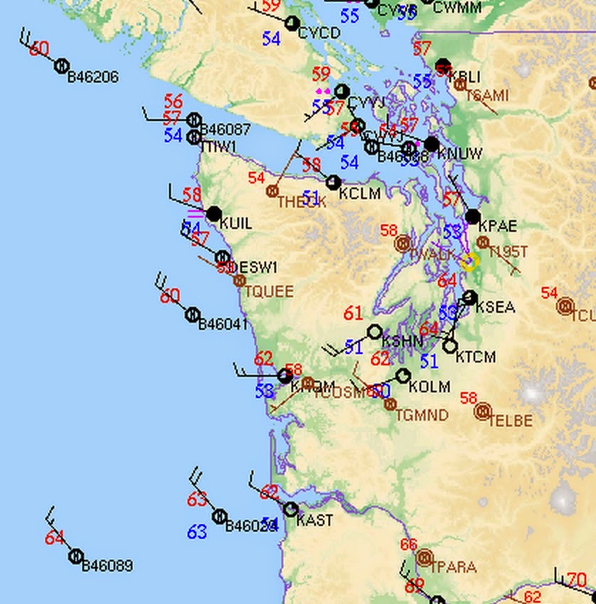
To illustrate the amazing sharpness of the convergence zone, here is the record at the University of Washington of its passage. Time is in UTC (GMT), with 0000 UTC being 5 PM. The 6th panel is precipitation....the trace went straight up by around .2 inches in a few minutes. You can see the sudden drop in temperature (third panel) and the sudden shift in the wind direction (second panel).
Amazingly sharp transition.

Seems like kind of wimpy winds to cause power failures, right? We would laugh at such winds during the mid-winter. But this is the first storm of the season. Trees have their leaves (which act as sails) and all the new growth since last winter has been untested by wind. The first event syndrome.
(As an aside you got to really appreciate the power line crews working to restore power in the rain after this kind of event--these folks are heroic, working in the rain and adverse conditions to get the power back on!)
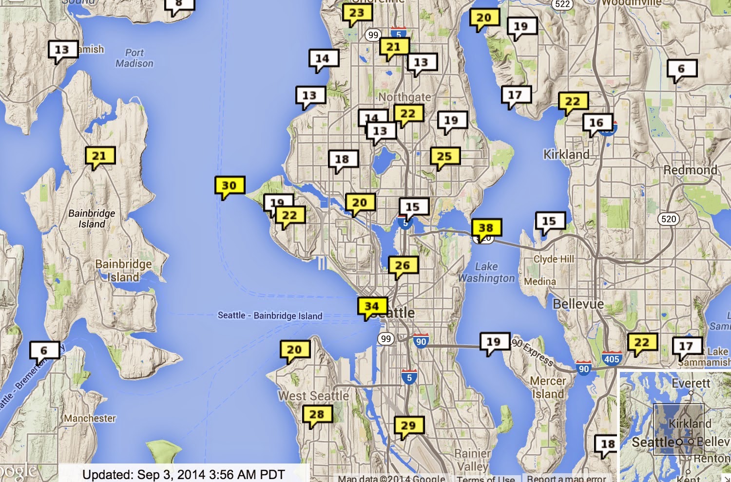
Finally, a convergence zone subtlety for those who appreciate such things. The strongest winds with convergence zones are often in the southerlies/southwesterlies south of the convergence line. To show this, here is a wind forecast for 5 PM from the UW WRF model. The yellows are sustained winds of around 20 kts (not gusts, which would be larger). If you look closely, you can see the wind barbs that provide the directions. Solid lines are sea level pressure. Very good forecast by the way.

This forecast drove a very skillful warning to Seattle City Light on their WindWatch application, giving their crews a heads-up to be ready.
If anyone is interested, I will be doing a weather segment on SandBox radio...the Seattle version of Prairie Home Companion. Will take place at ACT Theater, downtown Seattle, this Monday evening (Sept 8). To spice it up, Steve Scher will be on the program as well! For more information: check here.


5if you think it was fun in seattle, you should have been in the provinces. issaquah home depot sounded like a battle zone, and then the cell came up the hill to north bend. entire downtown north bend was dark by 9pm. unfortunately the road along the middle fork of the snoqualmie is closed for road work, but i expect it's pretty interesting up there today. who knows how many fish got shoved over the falls? it surely was exciting though.
ReplyDeleteI live in North Bend, near the base of Mt Si, and our rain gauge had 2.7" in it this morning. Not the kind of rain I associate with early September.
ReplyDeleteI got caught in it walking with the dog in Redmond. It was a half mile back to the car and all I could do was laugh at how ridiculously wet we both were. We were walking past a brewhouse and the dog ran up to the glass door - peering in imploring people to let her in! We took shelter inside for a while. Pretty funny. The streets were flooded, downspouts gushing and clothes dripping. I won't soon forget that storm.
ReplyDeleteJust south of Chehalis: After threats of rain from dark clouds, and signs of rain to the north and west much of the afternoon we quit exterior painting. At about 8PM a likely flash of lightning and a few minutes of very heavy rains, oddly enough without all that much wind (I forgot to check the weather station)
ReplyDeleteThere was another bout of heavy rain (at my place, on the Bothell mill-creek line) in the wee hours. I slept on the porch for the fresh air I figured was coming, and a little after midnight there was an intense burst of rain, but I was disappointed that I didn't get any lightning...
ReplyDelete